Wuyishan
Wuyishan (武夷山 ; pinyin : Wǔyíshān) est une ville-district de la province chinoise du Fujian. Elle est placée sous la juridiction de la ville-préfecture de Nanping et doit son nom à une célèbre montagne située sur son territoire, le mont Wuyi.
| Wǔyíshān 武夷山 | |

| |
| Administration | |
|---|---|
| Pays | |
| Province ou région autonome | Fujian |
| Préfecture | Nanping |
| Statut administratif | Ville-district |
| Code postal | 354300[1] |
| Indicatif | +86 (0) |
| Démographie | |
| 212 811 hab. (1999) | |
| Densité | 76 hab./km2 |
| Géographie | |
| Coordonnées | 27° 46′ 00″ nord, 118° 02′ 00″ est |
| Superficie | 280 271 ha = 2 802,71 km2 |
| Localisation | |
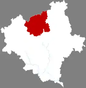 Localisation dans la préfecture de Nanping. | |
| Liens | |
| Site web | www.wys.gov.cn |
Subdivisions administratives
| Nom français (pinyin) | Type | Nom chinois |
|---|---|---|
| Chongan | sous-district | 崇安街道 |
| Xinfeng | sous-district | 新丰街道 |
| Xingcun | bourg | 星村镇 |
| Xingtian | bourg | 兴田镇 |
| Wufu | bourg | 五夫镇 |
| Shangmei | canton | 上梅乡 |
| Wutun | canton | (吴屯乡 |
| Langu | canton | 岚谷乡 |
| Yangzhuang | canton | 洋庄乡 |
Démographie
La population du district était de 212 811 habitants en 1999[2].
Notes et références
- (en) Codes postaux et téléphoniques du Fujian, (en) China Zip Code/ Telephone Code, ChinaTravel.
- (en) National Population Statistics Materials by County and City - 1999 Period, in « China County & City Population 1999 », sur Harvard China Historical GIS (version du sur Internet Archive)
Voir aussi
Cet article est issu de Wikipedia. Le texte est sous licence Creative Commons – Attribution – Partage à l’identique. Des conditions supplémentaires peuvent s’appliquer aux fichiers multimédias.