Þingeyjarsveit
Þingeyjarsveit est une municipalité du nord de l'Islande.
| Þingeyjarsveit | |
 Héraldique |
|

| |
| Administration | |
|---|---|
| Pays | |
| Région | Norðurland eystra |
| Circonscription | Norðausturkjördæmi |
| Comté | Suður-Þingeyjarsýsla |
| Maire Mandat |
Tryggvi Harðarson (2010-2014) |
| Code postal | 601, 641, 645, 650 |
| Code municipal | 6612 |
| Démographie | |
| Population | 867 hab. (2022) |
| Densité | 72 hab./km2 |
| Géographie | |
| Coordonnées | 65° 43′ 22″ nord, 17° 21′ 34″ ouest |
| Superficie | 1 202,1 ha = 12,021 km2 |
| Localisation | |
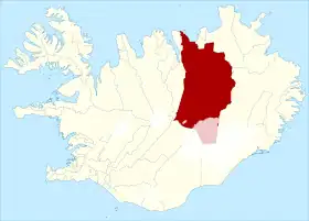 Situation de Þingeyjarsveit | |
| Liens | |
| Site web | https://www.thingeyjarsveit.is/ |
Histoire
En 2006, Þingeyjarsveit a absorbé la municipalité d'Aðaldælahreppur qui comptait 256 habitants au .
En mai 2022, la municipalité absorbe avec Skútustaðahreppur.
Démographie
 Portail de l’Islande
Cet article est issu de Wikipedia. Le texte est sous licence Creative Commons – Attribution – Partage à l’identique. Des conditions supplémentaires peuvent s’appliquer aux fichiers multimédias.