Route nationale 5 (Inde)
La route nationale 5 (National Highway 5) est une route nationale principale en Inde, allant d'ouest en est, s'étendant de Firozpur au Pendjab, à la frontière sino-indienne, jusqu'à Shipki La (en)[1].
| NH-5 | |

| |
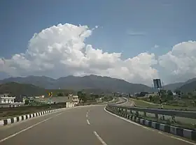 La NH5 et au fond la chaîne Siwalik. | |
| Caractéristiques | |
|---|---|
| Longueur | 1533 km |
| De | Firozpur |
| Intersections | |
| À | Shipki La (en) |
| Réseau | Agence des routes nationales de l'Inde |
| Territoires traversés | |
| Région | Pendjab, Chandigarh, Haryana, Himachal Pradesh |
| Villes principales | Moga, Jagraon, Ludhiana, Mohali, Chandigarh, Panchkula, Kalka, Solan, Shimla, Theog, Narkanda, Kumarsain, Rampur, Chini |
Tracé
La route traverse Moga (en), Jagraon, Ludhiana, Mohali, Chandigarh, Panchkula, Kalka, Solan, Shimla, Theog, Narkanda, Kumarsain, Rampur Bushahr et continue le long de la rivière Sutlej et se termine près de la frontière du Tibet.
- Punjab
Firozpur, Moga (en), Jagraon, Ludhiana, Kharar, Morinda, Mohali - Chandigarh border
- Punjab
Zirakpur
- Haryana
Panchkula, Surajpur, Pinjore
- Himachal Pradesh
Parwanoo, Solan, Shimla, Theog, Narkanda, Kumarsain, Rampur Bushahr, Chini, Shipki La (en)
Références
- « Rationalization of Numbering Systems of National Highways », Govt of India, (consulté le )
 Portail de la route
  Portail de l’Inde
Cet article est issu de Wikipedia. Le texte est sous licence Creative Commons – Attribution – Partage à l’identique. Des conditions supplémentaires peuvent s’appliquer aux fichiers multimédias.