Route nationale 52 (Inde)
La route nationale 52 (en anglais : National Highway 52, sigle NH 52), une route nationale en Inde qui relie Sangrur à Ankola[1],[2].
| Route nationale 52 | |

| |
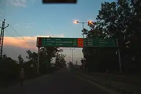 La route NH52 avant sa renumerotation de 2015. | |
| Caractéristiques | |
|---|---|
| Longueur | 2 317 km |
| De | Sangrur |
| À | Ankola |
| Territoires traversés | |
| Région | Punjab • Haryana • Rajasthan • Madhya Pradesh • Maharashtra • Karnataka |
Tracé
| État | Villes principales |
|---|---|
| Pendjab | Sangrur, Dirba, Pattran |
| Haryana | Narwana, Barwala, Uklana Mandi, Hisar, Siwani |
| Rajasthan | Sadulpur/Rajgarh, Churu, Ramgarh, Sikar, Fatehpur, Laxmangarh, Sikar, Palsana, Ringas, Chomu, Jaipur, Tonk, Bundi, Talera, Kota, Jhalawar, Aklera |
| Madhya Pradesh | Rajgarh, Biora, Dewas, Indore, Sendhwa |
| Maharashtra | Dhule, Chalisgaon, Kannad, Aurangabad, Georai, Bid, Chausala, Osmanabad, Tuljapur, Solapur |
| Karnataka | Dhulakhed, Zalaki, Horti, Basanal Cross, Agasanal, Bijapur, Kolhar, Bilagi, Gaddanakeri Cross, Bagalakote, Kerur, Nargund, Navalgund, Hubli, Kalaghatagi, Yellapura, Ramanaguli, Ankola |
Références
- « State-wise length of National Highways in India as on 30.06.2017 » [archive du ], sur National Highways Authority of India (consulté le )
- « New Numbering of National Highways notification - Government of India », sur The Gazette of India (consulté le )
Voir aussi
Liens externes
 Portail de la route
  Portail de l’Inde
Cet article est issu de Wikipedia. Le texte est sous licence Creative Commons – Attribution – Partage à l’identique. Des conditions supplémentaires peuvent s’appliquer aux fichiers multimédias.