District de Wiener Neustadt-Land
Le district de Wiener Neustadt-Land est une subdivision territoriale du Land de Basse-Autriche en Autriche.
| Wiener Neustadt-Land | |
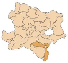 Localisation du district de Wiener Neustadt-Land dans le Land autrichien de Basse-Autriche. | |
| Administration | |
|---|---|
| Pays | |
| Land | |
| Centre administratif | Wiener Neustadt |
| Immatriculation | WB |
| Démographie | |
| Population | 77 991 hab. () |
| Densité | 80 hab./km2 |
| Géographie | |
| Coordonnées | 47° 37′ 21″ nord, 16° 20′ 27″ est |
| Superficie | 96 972 ha = 969,72 km2 |
| Localisation | |

Commission du District de Wiener Neustadt
Géographie
Lieux administratifs voisins
 |
||
Communes
Le district de Wiener Neustadt-Land est subdivisé en 35 communes :
- Bad Erlach
- Bad Fischau-Brunn
- Bad Schönau
- Bromberg
- Ebenfurth
- Eggendorf
- Felixdorf
- Gutenstein
- Hochneukirchen-Gschaidt
- Hochwolkersdorf
- Hohe Wand
- Hollenthon (Basse-Autriche)
- Katzelsdorf
- Kirchschlag in der Buckligen Welt
- Krumbach
- Lanzenkirchen
- Lichtenegg
- Lichtenwörth
- Markt Piesting
- Matzendorf-Hölles
- Miesenbach
- Muggendorf
- Pernitz
- Rohr im Gebirge
- Schwarzenbach
- Sollenau
- Theresienfeld
- Waidmannsfeld
- Waldegg
- Walpersbach
- Weikersdorf am Steinfelde
- Wiesmath
- Winzendorf-Muthmannsdorf
- Wöllersdorf-Steinabrückl
- Zillingdorf
Carte interactive des communes du district de Wiener Neustadt-Land
Notes et références
 Portail de l'Autriche
Cet article est issu de Wikipedia. Le texte est sous licence Creative Commons – Attribution – Partage à l’identique. Des conditions supplémentaires peuvent s’appliquer aux fichiers multimédias.